Negative
24Serious
Neutral
Optimistic
Positive
- Total News Sources
- 1
- Left
- 0
- Center
- 0
- Right
- 0
- Unrated
- 1
- Last Updated
- 2 days ago
- Bias Distribution
- 100% Unrated
Rains Yield Mixed Drought Changes Across Southeast
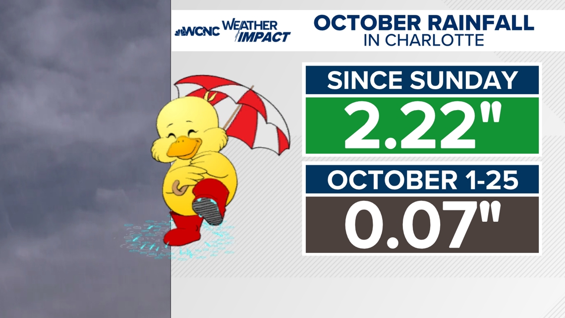
This week's Drought Monitor and the Climate Prediction Center show mixed outcomes across the Southeast and Gulf Coast after heavy weekend rains. Parts of St. Tammany Parish’s North Shore improved from Moderate to Abnormally Dry, Hancock County, Mississippi improved, and a triangle near Bay St. Louis eased from Severe to Moderate. Broad improvements were recorded across Texas, Oklahoma, Louisiana, Mississippi and Tennessee after 2–4+ inch totals in spots, helping the Trinity and Neches basins and prompting several East Texas counties to lift burn bans, though dry pockets near the Sabine River and in Deep East Texas persist. New Orleans remains slightly below its year-to-date normal (52.90 in vs. 54.64 in), and Charlotte saw roughly 2.22 inches yet no change on the Drought Monitor — the area would need about 8.5 inches in one month (or 14.5 inches in three months) to fully exit drought. Meanwhile, Southeast Texas has worsened after an exceptionally dry October with some counties moving into Severe drought while central Texas eased down from Extreme levels, and parts of New Hampshire improved from Extreme to Severe but remain below seasonal averages.
- Total News Sources
- 1
- Left
- 0
- Center
- 0
- Right
- 0
- Unrated
- 1
- Last Updated
- 2 days ago
- Bias Distribution
- 100% Unrated
Negative
24Serious
Neutral
Optimistic
Positive
Stay in the know
Get the latest news, exclusive insights, and curated content delivered straight to your inbox.

Gift Subscriptions
The perfect gift for understanding
news from all angles.